June 12, 2006
The Tornado’s Potential
Destruction
By Dr. Frank J. Collazo
Introduction:
A tornado is a violently rotating column of air extending
from within a thundercloud down to ground level. The strongest tornadoes may sweep houses from their foundations,
destroy brick buildings, toss cars and school buses through the air, and even
lift railroad cars from their tracks.
Tornadoes vary in diameter from tens of meters to nearly 2 km (1 mi),
with an average diameter of about 50 m (160 ft). Most tornadoes in the northern hemisphere create winds that blow
counterclockwise around a center of extremely low atmospheric pressure. In the southern hemisphere the winds
generally blow clockwise. Peak wind
speeds can range from near 120 km/h (75 mph) to almost 500 km/h (300 mph). The forward motion of a tornado can range
from a near standstill to almost 110 km/h (70 mph).
What is a
tornado? According to the Glossary of
Meteorology (AMS 2000) a tornado is "a violently rotating column of air,
pendant from a cumuliform cloud or underneath a cumuliform cloud, and often
(but not always) visible as a funnel cloud." Literally, in order for a vortex to be classified as a tornado,
it must be in contact with the ground and the cloud base. Weather scientists haven't found it so
simple in practice, however, to classify and define tornadoes. For example, the difference is unclear
between a strong mesocyclone (parent thunderstorm circulation) on the ground,
and a large, weak tornado. There is also disagreement as to whether separate
touchdowns of the same funnel constitute separate tornadoes.
It is well known that a tornado may not have a visible
funnel. Also, at what wind speed of the
cloud-to-ground vortex does a tornado begin?
How close must two or more different tornadic circulations become to
qualify as a one multiple-vortex tornado instead of separate tornadoes? There are no firm answers.
Figure 2 - Formation of a
Tornado
Many tornadoes, including the strongest ones, develop from a special type of thunderstorm known as a super-cell. A super-cell is a long-lived, rotating thunderstorm 10 to 16 km (6 to 10 mi) in diameter that may last several hours, travel hundreds of miles, and produce several tornadoes. Super-cell tornadoes are often produced in sequence, so that what appears to be a very long damage path from one tornado may actually be the result of a new tornado that forms in the area where the previous tornado died. Sometimes, tornado outbreaks occur, and swarms of super-cell storms may occur. Each super-cell may spawn a tornado or a sequence of tornadoes.
The complete process of tornado formation in super-cells
is still debated among meteorologists.
Scientists generally agree that the first stage in tornado formation is
an interaction between the storm updraft and the winds. An updraft is a current of warm, moist air
that rises upward through the thunderstorm.
The updraft interacts with the winds, which must change with height in
favorable ways for the interaction to occur.
This interaction causes the updraft to rotate at the middle levels of
the atmosphere. The rotating updraft,
known as a meso-cyclone, stabilizes the thunderstorm and gives it its
long-lived super- cell characteristics.
The next stage is the development of a strong downdraft (a current of cooler air that moves in a downward direction) on the backside of the storm, known as a rear-flank downdraft. It is not clear whether the rear-flank downdraft is induced by rainfall or by pressure forces set up in the storm, although it becomes progressively colder as the rain evaporates into it. This cold air moves downward because it is denser than warm air. The speed of the downdraft increases and the air plunges to the ground, where it fans out at speeds that can exceed 160 km/h (100 mph). The favored location for the development of a tornado is at the area between this rear-flank downdraft and the main storm updraft. However, the details of why a tornado should form there are still not clear.
The same condensation process that creates tornadoes makes visible the generally weaker sea-going tornadoes, called waterspouts. Waterspouts occur most frequently in tropical waters.
Types of Tornadoes
Tornado Twister: A tornado that's 500 meters in diameter
looks a lot more ominous than the average twister, which is "only"
150 meters across. But tornado size is
not related to wind speed, or to damage intensity. Instead, wind speed increases along with the difference between
atmospheric pressure inside the funnel and the pressure outside it (the core
pressure difference). The larger the
difference in atmospheric pressure between the core and the surrounding air,
the faster the winds. But at a given wind speed, a larger
tornado will do more total damage.
Gustnado: A gustnado is a small and
usually weak whirlwind, which forms as an eddy in thunderstorm outflows. They do not connect with any cloud-base
rotation and are not tornadoes. But
because gustnadoes often have a spinning dust cloud at ground level, they are
sometimes wrongly reported as tornadoes.
Gustnadoes can do minor damage such as: break windows and tree limbs,
overturn trashcans and toss lawn furniture, and should be avoided.
Wedge" Tornado and a "Rope" Tornado: These are slang terms
often used by storm observers to describe tornado shape and appearance. Remember, the size or shape of a tornado
does not say anything certain about its strength!
Wedge tornadoes simply appear to be at least as wide as they are
tall (from ground to ambient cloud base).
Rope tornadoes are
very narrow, often sinuous or snake-like in form. Tornadoes often (but not always!) assume the "rope"
shape in their last stage of life, and the cloud rope may even break up into
segments. Again, tornado shape and size
does not signal strength! Some rope tornadoes
can still do violent damage of F4 or F5.
A "Satellite" Tornado: Is it a kind of multi-vortex tornado? No.
There are important distinctions between satellite and multiple-vortex
tornadoes. A satellite tornado develops
independently from the primary tornado -- not inside it, as does a suction
vortex. The tornadoes remain separate
and distinct as the satellite tornado orbits its much larger companion within
the same mesocyclone. Their cause is
unknown; but they seem to form most often in the vicinity of exceptionally
large and intense tornadoes.
Land Spout: This is storm-chaser slang for a non-super cell
tornado. So-called "land
spouts" resemble waterspouts in that way, and also in their typically
small size and weakness compared to the most intense tornadoes. But "land spouts" are tornadoes by
definition, and they are capable of doing significant damage and killing
people.
Spinning Like Dynamo Energy (Energy Generation Basics): Scientifically speaking,
it's the ability to do work (that's one of the plainest definitions in
science). Energy takes many forms,
including chemical, kinetic, potential and thermal. Energy can change forms.
You know the drill: Solar energy creates chemical energy in plants,
which eventually become petroleum. When
your Nash Metropolitan burns gasoline, it becomes heat energy, which then
becomes kinetic energy. And when
(should we say "if") your brakes stop that Nash, the kinetic energy
is transformed again into heat energy.
A different set of energy transformations power the furious winds
of a twister. Like your car, tornadoes
also get their energy from the sun.
When the sun warms the ocean, water evaporates and carries potential
energy, called the latent heat of vaporization, into the atmosphere. When the water vapor rises, cools and
condenses inside a thunderstorm, the latent heat of condensation is
released. According to Robert
Davies-Jones of the National Severe Storms Laboratory, this latent heat is the
biggest single source of energy in a thunderstorm. When the latent heat is released, it warms the rising air,
causing a difference in density that pushes the air up at the extreme speeds
needed to create a tornado.
Tornadoes release a boatload of energy, says Davies-Jones. A tornado with wind speeds of 200 mph
releases kinetic energy at the rate of 1 billion watts -- equal to the electric
output of a pair of large nuclear reactors.
But that's just processed cheese compared to the large thunderstorms
that can spawn tornadoes. These
monsters release latent heat at the rate of 40 trillion watts -- 40,000 times
as powerful as the puny twister, Davies-Jones says.
Virtuous Vortex: A tornado is a type of vortex -- a
spinning column of air with some water vapor.
You can make a tornado quite easily.

Take
two 2-liter soda bottles, fill one with water and some food coloring, and
connect the bottles with a "tornado tube" (available from Edmund Scientific and many toy
stores). If you're feeling cheap,
Dorothy suggests old-fashioned duct tape.
One tube will be upside down, the other right side up.
Move
the water-filled bottle to the top, give the bottles a twist, and a vortex will
flow into the lower bottle.
How do you forecast tornadoes? This is a very simple question with no
simple answer! Here is a very generalized view from the perspective of a severe
weather forecaster: When predicting severe weather (including tornadoes) a day
or two in advance, we look for the development of temperature and wind flow
patterns in the atmosphere which can cause enough moisture, instability, lift,
and wind shear for tornadic thunderstorms.
Those are the four needed ingredients. But it is not as easy as it sounds. "How much is enough" of those is not a hard fast
number, but varies a lot from situation to situation -- and sometimes is unknown!
A large variety of weather patterns can lead to tornadoes; and
often, similar patterns may produce no severe weather at all. To further complicate it, the various
computer models we use days in advance can have major biases and flaws when the
forecaster tries to interpret them on the scale of thunderstorms. As the event gets closer, the forecast
usually (but not always) loses some uncertainty and narrows down to a more
precise threat area. Real-time weather
observations -- from satellites, weather stations, balloon packages, airplanes,
wind profilers and radar-derived winds -- become more and more critical the
sooner the thunderstorms are expected; and the models become less important.
To figure out
where the thunderstorms will form, we must do some hard, short-fuse detective
work: Find out the location, strength and movement of the fronts, dry lines,
outflows, and other boundaries between air masses which tend to provide
lift. Figure out the moisture and
temperatures -- both near ground and aloft -- which will help storms form and
stay alive in this situation. Find the
wind structures in the atmosphere, which can make a thunderstorm, rotate as a
super cell, and then produce tornadoes.
Make an educated guess where the most favorable combination of
ingredients will be and when; then draw the areas and type the forecast.
What direction do tornadoes come from? Does the region of the US
play a role in path direction?
Tornadoes can appear from any direction. Most move from southwest to northeast, or west to east. Some tornadoes have changed direction amid
path, or even backtracked. [A tornado can double back suddenly, for example,
when its bottom is hit by outflow winds from a thunderstorm's core.] Some areas of the US tend to have more paths
from a specific direction, such as northwest in Minnesota or southeast in
coastal south Texas. This is because of
an increased frequency of certain tornado-producing weather patterns (say,
hurricanes in south Texas, or northwest-flow weather systems in the upper
Midwest).
Hail leading tornado rain?
Lightning? Utter silence? Not
necessarily, for any of those. Rain,
wind, lightning, and hail characteristics vary from storm to storm, from one
hour to the next, and even with the direction the storm is moving with respect
to the observer. While large hail can
indicate the presence of an unusually dangerous thunderstorm, and can happen
before a tornado, don't depend on it.
Hail, or any particular pattern of rain, lightning or calmness, is not a
reliable predictor of tornado threat.
How do tornadoes dissipate? The details are still debated by tornado
scientists. We do know tornadoes need a
source of instability (heat, moisture, etc.) and a larger-scale property of
rotation of vortices to keep going.
There are a lot of processes around a thunderstorm, which can possibly
rob the area around a tornado of either instability or vorticity. One is relatively cold outflow -- the flow
of wind out of the precipitation area of a shower or thunderstorm. Many tornadoes have been observed to go away
soon after being hit by outflow. For
decades, storm observers have documented the death of numerous tornadoes when
their parent circulations (meso-cyclones) weaken after they become wrapped in
outflow air -- either from the same thunderstorm or a different one. The irony
is that some kinds of thunderstorm outflow may help to cause tornadoes, while
other forms of outflow may kill tornadoes.
How long does a tornado last? Tornadoes can last from several seconds to
more than an hour. The longest-lived
tornado in history is really unknown, because so many of the long-lived
tornadoes reported from the early 1900s and before are believed to be tornado
series instead. Most tornadoes last
less than 10 minutes.
How close to a tornado does the barometer drop? And how far does it drop? It varies. A barometer
can start dropping many hours or even days in advance of a tornado if there is
low pressure on a broad scale moving into the area. Strong pressure falls will often happen as the mesocyclone
(parent circulation in the thunderstorm) moves overhead or nearby. The biggest drop will be in the tornado
itself, of course. It is very hard to
measure pressure in tornadoes since most weather instruments can't
survive.
A few low-lying, armored
probes called "turtles" have been placed successfully in
tornadoes. This includes one deployment
on 15 May 2003 by engineer/storm chaser Tim Samaras, who recorded pressure fall
of over 40 millibars through an unusually large tornado. On 24 June 2003, another of Tim's probes
recorded a 100 millibars pressure plunge in a violent tornado near Manchester,
SD. Despite those spectacular results,
and a few fortuitous passes over barometers through history, we still do not
have a database of tornado pressures big enough to say much about average tornado
pressures or other barometric characteristics.
What is a waterspout? A waterspout is a tornado over water --
usually meaning non-super cell tornadoes over water. Waterspouts are common along the southeast U.S. coast --
especially off southern Florida and the Keys -- and can happen over seas, bays
and lakes worldwide. Although
waterspouts are always tornadoes by definition; they don't officially count in
tornado records unless they hit land.
They are smaller and weaker than the most intense Great Plains
tornadoes, but still can be quite dangerous.
Waterspouts can overturn small boats, damage ships, do significant
damage when hitting land, and kill people.
The National Weather Service will often issue special marine warnings
when waterspouts are likely or have been sighted over coastal waters, or
tornado warnings when waterspouts can move onshore.
How are tornadoes in the northern hemisphere different from
tornadoes in the southern hemisphere? The sense of rotation is usually the
opposite. Most tornadoes, but not all,
rotate cyclonically, which is counterclockwise in the northern hemisphere and
clockwise south of the equator.
Anti-cyclonic tornadoes (clockwise-spinning in the northern hemisphere)
have been observed, however -- usually in the form of waterspouts, non-super
cell land tornadoes, or anticyclone whirls around the rim of a super cell’s
mesocyclone. There have been several
documented cases of cyclonic and anticyclone tornadoes under the same
thunderstorm at the same time.
Anti-cyclonically, rotating super cells with tornadoes are extremely
rare; but one struck near Sunnyvale, CA, in 1998. Remember, "cyclonic" tornadoes spin counter-clockwise
in the northern hemisphere.
What is a multi-vortex tornado?
Multi-vortex (a.k.a. multiple-vortex) tornadoes contain two or more small,
intense sub-vortices orbiting the center of the larger tornado
circulation. When a tornado does not
contain too much dust and debris, they can sometimes be spectacularly visible. These vortices may form and die within a few
seconds, sometimes appearing to train through the same part of the tornado one
after another. They can happen in all
sorts of tornado sizes, from huge "wedge" tornadoes to narrow
"rope" tornadoes.
Sub-vortices are the cause of most of the narrow, short, extreme swaths
of damage that sometimes arc through tornado tracks. From the air, they can preferentially mow down crops and stack
the stubble, leaving cycloid marks in fields. Multi-vortex tornadoes are the
source of most of the old stories from newspapers and other media before the
late 20th century, which told of several tornadoes seen together at once.
Tornado
Watching: The picture depicted below of a
meteorologist tracking a tornado as part of ongoing weather observations to
better understand the earth’s atmosphere.
Since the 19th century, scientific forecasting has greatly
improved. Weather radar can detect and
track tornados, hurricanes, and other severe storms.
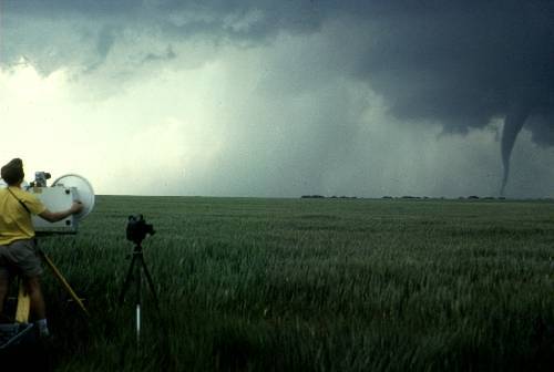
Figure 1 - Photo Researchers, Inc./Howard Bluestein/Science
Source-Tornado Tracking
Visibility of a Tornado: A tornado becomes visible when a
condensation funnel made of water vapor (a funnel cloud) forms in extreme low
pressures, or when the tornado lofts dust, dirt, and debris upward from the
ground. A mature tornado may be
columnar or tilted, narrow or broad—sometimes so broad that it appears as if
the parent thundercloud itself had descended to ground level. Some tornadoes resemble a swaying elephant's
trunk. Others, especially very violent
ones, may break into several intense suction vortices—intense swirling masses
of air—each of which rotates near the parent tornado. A suction vortex may be only a few meters in diameter, and thus
can destroy one house while leaving a neighboring house relatively unscathed.
Tornadoes Studied by Scientists: Scientists study tornadoes to gain a better
understanding of their formation, behavior, and structure. Scientists who study tornadoes have a
variety of powerful research tools at their disposal. Advances in computer technology make it possible to simulate the
thunderstorms that spawn tornadoes using computer models running on desktop
computers. Doppler radars, which detect
the rain in clouds, allow meteorologists, scientists who study weather, to
"see" the winds inside the storms that spawn tornadoes. Modern video camera footage and reports from
trained storm-spotters provide an unprecedented amount of high-quality tornado
documentation. These tools all
contribute greatly to the scientific understanding of tornadoes. This information may eventually lead to
increased tornado warning times, better guidelines for building construction
(especially schools) and improved safety tips.
How is tornado damage rated? The most widely used method worldwide for
over three decades was the F-scale developed by Dr. T. Theodore Fujita. In the U.S., and probably elsewhere within a
few years, the new Enhanced F-scale is becoming the standard for assessing
tornado damage. In Britain, there is a
scale similar to the original F-scale but with more divisions; for more info,
go to the TORRO scale website. In both
original F- and TORRO-scales, the wind speeds are based on calculations of the
Beaufort wind scale and have never been scientifically verified in real
tornadoes. Enhanced F-scale winds are
derived from engineering guidelines but still are only judgmental
estimates. Because:
- Nobody
knows the "true" wind speeds at ground level in most tornadoes,
and
- The amount
of wind needed to do similar-looking damage can vary greatly, even from
block to block or building to building,
Damage rating is (at best) is an exercise in educated
guessing. Even experienced
damage-survey meteorologists and wind engineers can and often do disagree among
themselves on a tornado's strength.
Damage Assessment Protection by a Tornado: Many houses close to a twister are damaged or destroyed by wind, rain and flying debris. These homes and their occupants can benefit from simple, relatively cheap measures to drastically reduce damage, Wolfe adds. Many of these improvements concern the roof, which often fails first in windstorms. Once that happens, Wolfe says, torrential rain can soak the insulation and drywall and the walls, no longer braced from above, can collapse.
![]() Roof shingles
are usually the first to go, Wolfe says.
Shingles near roof edges, which face the worst winds, should be set in
special mastic during re-shingling.
Roof shingles
are usually the first to go, Wolfe says.
Shingles near roof edges, which face the worst winds, should be set in
special mastic during re-shingling.
![]() Roof sheathing, usually a material like plywood, should be
nailed securely to the rafters. Nails
should be 6 inches apart at the edges and 12 inches apart elsewhere.
Roof sheathing, usually a material like plywood, should be
nailed securely to the rafters. Nails
should be 6 inches apart at the edges and 12 inches apart elsewhere.
![]() Rafter fastening is critical.
These angled beams, which support the roof sheathing, were traditionally
nailed to the walls. This is extremely
weak, Wolfe says, partly because the nails tend to split the rafters. Simple, cheap "hurricane clips"
make a connection that is 5 to 15 times stronger.
Rafter fastening is critical.
These angled beams, which support the roof sheathing, were traditionally
nailed to the walls. This is extremely
weak, Wolfe says, partly because the nails tend to split the rafters. Simple, cheap "hurricane clips"
make a connection that is 5 to 15 times stronger.
![]() Foundation anchors keep a house from blowing away in one piece. Even though Wisconsin’s building code
required that houses be bolted to foundations, Wolfe says the attachments were
missing from many wrecked homes in Barneveld.
Although builders thought the attachments were unnecessary, he says, the
tornado proved them wrong.
Foundation anchors keep a house from blowing away in one piece. Even though Wisconsin’s building code
required that houses be bolted to foundations, Wolfe says the attachments were
missing from many wrecked homes in Barneveld.
Although builders thought the attachments were unnecessary, he says, the
tornado proved them wrong.
Mobile Homes: Mobile homes present special problems in tornadoes. The best advice is to leave them for
underground shelter, says James McDonald, professor of civil engineering at
Texas Tech University in Lubbock, who also directs the Institute for Disaster
Research. "There's not a whole lot
you can do because of the way they are constructed. It's a very lightweight structure with a large, exposed surface
area ... that's built with very little margin for error." A 1993 federal regulation, passed in
response to Hurricane Andrew, raised building standards. New mobile homes must withstand 30 to 40
percent faster winds, McDonald says (previously, homes were supposed to survive
winds of only 60 mph). Stronger
fastenings must be used inside the home, especially at exterior corners. But a mobile home that remains intact must
also remain in place.
The standard anchoring technique, McDonald says, is to drive big
steel screws into the ground. "But
there's a catch-22. If the ground is
soft enough for the anchor to penetrate, the soil is too soft to prevent it
from pulling out. If the ground is
stronger, the stake won't go in deeply enough." McDonald (see "Review of Standard Practice. ..." In the bibliography) notes that "95
percent of mobile homes are never moved after they are placed." Thus he advocates anchoring mobile homes to
concrete foundations, an expensive measure but one that can be done to existing
homes. Still, given the drawbacks of
lightweight construction and lack of a basement, McDonald says he would not
feel comfortable riding out a tornado warning in a new-standard mobile home,
even if it was bolted to a concrete foundation.
Classification of Tornadoes
What is the original F-scale? Dr. T. Theodore Fujita developed a damage
scale (Fujita 1971, Fujita and Pearson 1973) for winds, including tornadoes,
which was supposed to relate the degree of damage to the intensity of the wind. This scale was the result. The original F-scale should not be used
anymore, because it has been replaced by an enhanced version. Tornado wind speeds are still largely
unknown; and the wind speeds on the original F-scale have never been
scientifically tested and proven. Different
winds may be needed to cause the same damage depending on how well built a
structure is, wind direction, wind duration, battering by flying debris, and a
bunch of other factors.
Also, the process of rating the damage itself is largely a
judgment call -- quite inconsistent and arbitrary (Doswell and Burgess,
1988). Even meteorologists and
engineers highly experienced in damage survey techniques often came up with
different F-scale ratings for the same damage.
Even with all its flaws, the original F-scale was the only widely used
tornado rating method for over three decades.
The enhanced F-scale takes effect 1 February 2007.
What is the Enhanced F-scale? The Enhanced F-scale is a much more precise
and robust way to assess tornado damage than the original. It classifies F0-F5 damage as calibrated by
engineers and meteorologists across 28 different types of damage indicators
(mainly various kinds of buildings, but also a few other structures as well as
trees). The idea is that a "one
size fits all" approach just doesn't work in rating tornado damage, and
that a tornado scale needs to take into account the typical strengths and
weaknesses of different types of construction.
This is because the same wind does different things to different kinds
of structures. In the Enhanced F-scale,
there will be different, customized standards for assigning any given F rating
to a well built, well anchored wood-frame house compared to a garage, school,
skyscraper, unanchored house, barn, factory, utility pole or other type of
structure.
In a real-life tornado track, these ratings can be mapped together
more smoothly to make a damage analysis.
Of course, there still will be gaps and weaknesses on a track where
there was little or nothing to damage, but such problems will be less common
than under the original F-scale. As
with the original F-scale, the enhanced version will rate the tornado as a
whole based on most intense damage within the path. The enhanced F-scale takes effect 1 February 2007.
The
following table is an update to the original F-scale by
a team of meteorologists and wind engineers, to be implemented in the U.S. on 1
February 2007.
Table I - Enhanced F
Scale for Tornado Damage
|
Fujita Scale |
Derived EF Scale |
Operational
EF Scale |
||||
|
F Number |
Fastest 1/4-mile (mph) |
3 Second Gust (mph) |
EF Number |
3 Second Gust (mph) |
EF Number |
3 Second Gust (mph) |
|
0 |
40-72 |
45-78 |
0 |
65-85 |
0 |
65-85 |
|
1 |
73-112 |
79-117 |
1 |
86-109 |
1 |
86-110 |
|
2 |
113-157 |
118-161 |
2 |
110-137 |
2 |
111-135 |
|
3 |
158-207 |
162-209 |
3 |
138-167 |
3 |
136-165 |
|
4 |
208-260 |
210-261 |
4 |
168-199 |
4 |
166-200 |
|
5 |
261-318 |
262-317 |
5 |
200-234 |
5 |
Over 200 |
Table
II - Enhanced F Scale Damage Indicators
Number (Details Linked)
Damage Indicator Abbreviation
|
Number (Details Linked) |
Damage Indicator |
Abbreviation |
|
Small barns, farm
outbuildings |
SBO |
|
|
One- or two-family
residences |
FR12 |
|
|
Single-wide mobile
home (MHSW) |
MHSW |
|
|
Double-wide mobile
home |
MHDW |
|
|
Apt, condo, townhouse
(3 stories or less) |
ACT |
|
|
Motel |
M |
|
|
Masonry apt. or motel |
MAM |
|
|
Small retail bldg.
(fast food) |
SRB |
|
|
Small professional
(doctor office, branch bank) |
SPB |
|
|
Strip mall |
SM |
|
|
Large shopping mall |
LSM |
|
|
Large, isolated
("big box") retail bldg. |
LIRB |
|
|
Automobile showroom |
ASR |
|
|
Automotive service
building |
ASB |
|
|
School - 1-story
elementary (interior or exterior halls) |
ES |
|
|
School - jr. or sr.
high school |
JHSH |
|
|
Low-rise (1-4 story)
bldg. |
LRB |
|
|
Mid-rise (5-20 story)
bldg. |
MRB |
|
|
High-rise (over 20
stories) |
HRB |
|
|
Institutional bldg.
(hospital, govt. or university) |
IB |
|
|
Metal building system |
MBS |
|
|
Service station canopy |
SSC |
|
|
Warehouse (tilt-up
walls or heavy timber) |
WHB |
|
|
Transmission line
tower |
TLT |
|
|
Free-standing tower |
FST |
|
|
Free standing pole
(light, flag, luminary) |
FSP |
|
|
Tree - hardwood |
TH |
|
|
Tree - softwood |
TS |
What is a "significant" tornado? A tornado is classified
as "significant" if it does F2 or greater damage on the Enhanced F
scale. Grazulis (1993) also included
killer tornadoes of any damage scale in his significant tornado database. It is important to know that those
definitions are arbitrary, for scientific research. No tornado is necessarily insignificant. Any tornado can kill or cause damage; and
some tornadoes rated less than F2 probably could do F2 or greater damage if
they hit a well-built house during peak intensity.
How does cloud seeding affect tornadoes? Nobody knows, for
certain. There is no proof that cloud
seeding can or cannot change tornado potential in a thunderstorm. This is because there is no way to know that
the things a thunderstorm does after seeding would not have happened anyway. This includes any presence or lack of rain,
hail, wind gusts or tornadoes. Because
the effects of seeding are impossible to prove or disprove, there is a great
deal of controversy in meteorology about whether it works, and if so, under
what conditions, and to what extent.
What does a tornado sound like? That depends on what it is hitting, its
size, intensity, closeness and other factors.
The most common tornado sound is a continuous rumble, like a close by
train. Sometimes a tornado produces a
loud whooshing sound, like that of a waterfall or of open car windows while
driving very fast. Tornadoes, which are
tearing through densely populated areas, may be producing all kinds of loud
noises at once, which collectively may make a tremendous roar. Just because you may have heard a loud roar
during a damaging storm does not necessarily mean it was a tornado. Any intense thunderstorm wind can produce
damage and cause a roar.
Do hurricanes and tropical storms produce tornadoes? There are great
differences from storm to storm, not necessarily related to tropical cyclone
size or intensity. Some land falling
hurricanes in the U.S. fail to produce any known tornadoes, while others cause
major outbreaks. The same hurricane
also may have none for a while, then erupt with tornadoes...or vice versa. Andrew (1992), for example, spawned several
tornadoes across the Deep South after crossing the Gulf, but produced none
during its rampage across South Florida. Katrina (2005) spawned numerous
tornadoes after its devastating LA/MS landfall, but only one in Florida (in the
Keys). Though fewer tornadoes tend to
occur with tropical depressions and tropical storms than hurricanes, there are
notable exceptions like TS Beryl of 1994 in the Carolinas. Some tropical cyclones even produce two
distinct sets of tornadoes -- one around the time of landfall over Florida or
the Gulf Coast, the other when well inland or exiting the Atlantic coast.
Counter Measure Against Tornadoes (CMAT): Can't we weaken or
destroy tornadoes somehow, like by bombing them or sucking out their heat with
a bunch of dry ice? The main problem
with anything, which could realistically stand a chance at affecting a tornado,
is that it would be even more deadly and destructive than the tornado itself.
Lesser things (like huge piles of dry ice or smaller conventional weaponry)
would be too hard to deploy in the right place fast enough, and would likely
not have enough impact to affect the tornado much anyway. Imagine the legal problems one would face,
too, by trying to bomb or ice a tornado, then inadvertently hurting someone or
destroying private property in the process.
In short -- bad idea!
Classification Occurrence: In the United States, 75 percent of the
tornadoes rate F0 or F1 in strength.
Most remaining tornadoes rate F2 or F3, with only 1 percent rating F4 or
F5. Usually no more than one or two
tornadoes per year reach F5 strength.
On the other hand, the few F4 and F5 tornadoes account for 67 percent of
the fatalities caused by tornadoes.
Geography of Tornado Occurrence: The annual average occurrence of tornadoes in
the United States by state and sites of the biggest tornadoes in the period
from 1950 to 1999 are depicted below.
Most tornadoes occur in the central part of the country, in an area known
as Tornado Alley. Even in tornado alley, a twister hits a given square mile only
once every 700 years, Wolfe adds, "It's not economically feasible to build
a house to resist that kind of wind.
That's why you get insurance."
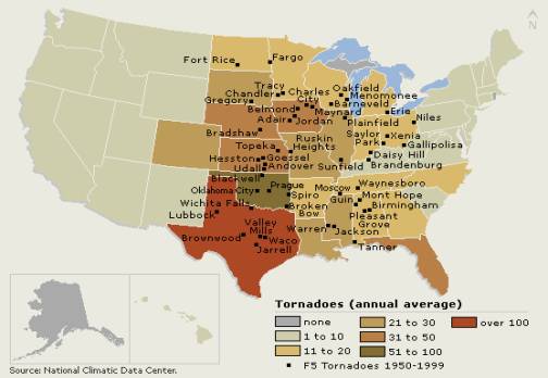
© Microsoft Corporation. All Rights Reserved.
Figure 3 -
Tornado Locations and Frequency
The United States has the highest
average annual number of tornadoes in the world, about 800 per year. Outside the United States, Australia ranks
second in tornado frequency. Tornadoes
also occur in many other countries, including China, India, Russia, England,
and Germany. Bangladesh has been struck several times by devastating killer
tornadoes.
In the United States, tornadoes occur in all 50 states. However, the region with the most tornadoes
is “Tornado Alley,” a swath of the Midwest extending from the Texas Gulf
Coastal Plain northward through eastern South Dakota. Another area of high concentration is “Dixie Alley,” which
extends across the Gulf Coastal Plain from south Texas eastward to
Florida. Tornadoes are most frequent in
the Midwest, where conditions are most favorable for the development of the
severe thunderstorms that produce tornadoes.
The Gulf of Mexico ensures a supply of moist, warm air that enables the
storms to survive. Weather conditions
that trigger severe thunderstorms are frequently in place here: convergence
(flowing together) of air along boundaries between dry and moist air masses,
convergence of air along the boundaries between warm and cold air masses, and
low pressure systems in the upper atmosphere traveling eastward across the
plains.
In winter, tornado activity is usually confined to the Gulf
Coastal Plain. In spring, the most
active tornado season, tornadoes typically occur in central Tornado Alley and
eastward into the Ohio Valley. In
summer, most tornadoes occur in a northern band stretching from the Dakotas
eastward into Pennsylvania and southern New York State.
The worst tornado disasters in the United States have claimed
hundreds of lives. The Tri-State
Outbreak of March 18, 1925, had the highest death toll: 740 people died in 7
tornadoes that struck Illinois, Missouri, and Indiana. The Super Outbreak of April 3-4, 1974,
spawned 148 tornadoes (the most in any known outbreak) and killed 315 people
from Alabama north to Ohio.
Protection Against Tornadoes
The Doppler Radar: The Image Doppler radar measures the speed
and direction of the movement of clouds, in addition to cloud density. The image depicted below is a thunderstorm
over Oklahoma, Doppler radar shows a mesocyclone, a rotating mass of air that
may signal that the formation of a tornado is imminent.
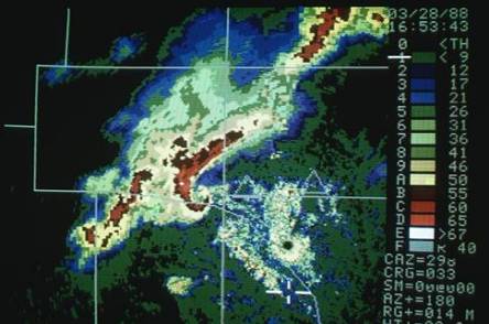
Bruce Coleman, Inc./Phil Designer
Figure 4 -
Doppler Radar Image, Bruce Coleman, Inc./Phil Degginger
The National
Weather Service alerts the public to severe weather hazards by issuing watches
and warnings that are broadcast on National Oceanic and Atmospheric
Administration (NOAA) weather radio, television, and commercial radio. Meteorologists issue a tornado watch when
weather conditions are favorable for the development of tornadoes and severe
thunderstorms. Watches are often issued
hours before severe weather develops and generally cover many counties or even
several states.
Tornado Watch : Issued by the National
Weather Service when weather conditions are ripe for tornadoes. Remind your family where to find
shelter. Turn on a radio or television
and listen for announcements. Since
tornado prediction is an inexact science, you may get little warning of an
actual funnel cloud.
Tornado Warning: A tornado warning means that a tornado is
occurring or is imminent. A warning is
issued if a tornado has touched down, if a funnel cloud is present, or if
Doppler radar indicates the presence of strong rotation in a thunderstorm updraft. The area covered by a warning is much
smaller than a watch, usually only a county or two, or a portion of a county.
Precautions: During a tornado warning, people should seek shelter immediately
in a basement or in the interior portion of a building (a closet, interior
hallway, or bathroom). Mobile homes and cars have a tendency to roll in high
winds and should therefore be abandoned.
Structures with large, free-span roofs, such as auditoriums, gymnasiums,
and supermarkets, are subject to collapse and should also be avoided. If caught outside, a person should lie flat
in a ditch and cover his or her head for protection from flying debris.
What is a safe room? So-called "safe rooms" are
reinforced small rooms built in the interior of a home, which are fortified by
concrete and/or steel to offer extra protection against tornadoes, hurricanes
and other severe windstorms. They can
be built in a basement, or if no basement is available, on the ground
floor. In existing homes, interior
bathrooms or closets can be fortified into "safe rooms" also.
What were the deadliest U.S. tornadoes? The
"Tri-state" tornado of 18 March 1925 killed 695 people as it raced
along at 60-73 mph in a 219-mile long track across parts of Missouri, Illinois
and Indiana, producing F5 damage. The
death toll is an estimate based on the work of Grazulis (1993); older
references have different counts. This
event also holds the known record for most tornado fatalities in a single city
or town: at least 234 at Murphysboro IL.
The 25 deadliest tornadoes on record are listed here. We also have web links related to this and
other major tornado events.
What were the deadliest U.S. tornado days? On 3 April
1974, the main day of the two-day "Super Outbreak," tornadoes killed
308 people. The next deadliest day for
tornadoes was 11 April 1965, the original "Palm Sunday Outbreak,"
where 260 perished. A list is online of top 20 deadliest tornado days since
detailed record keeping began in 1950.
The biggest known tornado (the Hallam, Nebraska F4 tornado) of 22
May 2004 is the newest record-holder for peak width, at nearly two and a half
miles, as surveyed by Brian Smith of NWS Omaha. This is probably close to the maximum size for tornadoes, but it
is possible that larger, unrecorded ones have occurred.
A single month had the most tornadoes. The record for most tornadoes in any month (since modern tornado
record keeping began in 1950) was set in May 2003, with 543 tornadoes confirmed
in the final numbers. This easily broke
the old mark of 399, set in June 1992.
Tornado Season: Tornado season usually means the peak period for historical
tornado reports in an area, when averaged over the history of reports. There is a general northward shift in "tornado
season" in the U.S. from late winter through mid summer. The peak period
for tornadoes in the southern plains, for example, is during May into early
June. On the Gulf coast, it is earlier
during the spring; in the northern plains and upper Midwest, it is June or
July.
The Highest-Elevation Tornado: Do they happen in the mountains West? The highest elevation a tornado has ever
occurred is unknown; but it is at least 10,000 feet above sea level. On 7 July 2004, a hiker observed and
photographed a tornado at 12,000 feet in Sequoia National Park,
California. That probably was the
highest elevation tornado observed in the U.S.
On 21 July 1987, there was a violent (F4 damage) tornado in Wyoming
between 8,500 and 10,000 feet in elevation, the highest altitude ever recorded
for a violent tornado. There was F3
damage from a tornado at up to 10,800 ft elevation in the Unita Mountains of
Utah on 11 August 1993.
While not so lofty in elevation, the Salt Lake City tornado of 11
August 1999 produced F2 damage. On
August 31, 2000, a super cell spawned a photogenic tornado in Nevada. Tornadoes
are generally a lot less frequent west of the Rockies per unit area with a
couple of exceptions. One exception is
the Los Angeles Basin, where weak-tornado frequency over tens of square miles
is on par with that in the Great Plains. Elsewhere, there are probably more
high-elevation Western tornadoes occurring than we have known about, just
because many areas are so sparsely populated, and they lack the density of
spotters and storm chasers as in the Plains.
The probability of a tornado near my house. The frequency that a
tornado can hit any particular square mile of land is about every thousand
years on average -- but it varies around the country. The reason this is not an exact number is because we don't have a
long and accurate enough record of tornadoes to make more certain
(statistically sound) calculations. The
probability of any tornado hitting within sight of a spot (let's say 25
nautical miles) also varies during the year and across the country. Detailed maps so you can judge the tornado
probabilities within 25 miles of your location have been engineered by Dr.
Harold Brooks of NSSL. He has used
statistical extensions of 1980-1994 tornado data, believed to be the most
representative to prepare many kinds of threat maps and animations.
The difference between a funnel cloud and a tornado. What is a funnel
cloud? In a tornado, a damaging
circulation is on the ground -- whether or not the cloud is. A true funnel cloud rotates, but has no
ground contact or debris, and is not doing damage. If it is a low-hanging cloud with no rotation, it is not a funnel
cloud. Caution: tornadoes can happen
without a funnel; and what looks like "only" a funnel cloud may be
doing damage, which can't be seen from a distance. Some funnels are high-based and may never touch down. Still, since a funnel cloud might quickly
become a tornado (remember rotation), it should be reported by spotters.
Some tornadoes are white, and others black or gray or even red: Tornadoes tend to look
darkest when looking southwest through northwest in the afternoon. In those cases, they are often silhouetted
in front of a light source, such as brighter skies west of the
thunderstorm. If there is heavy
precipitation behind the tornado, it may be dark gray, blue or even white --
depending on where most of the daylight is coming from. This happens often when the spotter is
looking north or east at a tornado, and part of the forward-flank and/or
rear-flank cores. Tornadoes wrapped in
rain may exhibit varieties of gray shades on gray, if they are visible at
all. Lower parts of tornadoes also can
assume the color of the dust and debris they are generating; for example, a
tornado passing across dry fields in western or central Oklahoma may take on
the hue of the red soil so prevalent there.
North America has the ingredients of a tornado. To understand this
phenomenon, consider the basic ingredients of a thunderstorm: warm, moist air
near the ground; dry air aloft (between altitudes of about three and 10
kilometers) and some mechanism such as a boundary between two air masses to
lift the warm, moist air upwards.
Storms that produce strong tornadoes are also most likely to occur when
the horizontal winds in the environment increase in speed and change with
increasing altitude. In the most common
directional change of this kind, the surface winds blow from the equator-ward
direction at the surface and out of the west a few kilometers above the
ground. When this wind pattern occurs
in the central part of the U.S., the surface winds come from the direction of
the Gulf of Mexico, bringing in warm, moist air at the surface, and the winds
aloft come from over the Rocky Mountains and are relatively dry. (Lifting air and heating it over a wide,
high range of mountains is an ideal way to dry it.) As a result, when the winds over the central part of the U.S are
correct for making thunderstorms, they often bring together the right
combination of the vertical temperature and moisture profile most likely to
produce tornadoes.
No other part of the world has the combination of a warm, moist
air source on the equator ward side and a wide, high range of mountains to the
west that extends for thousands of kilometers from north to south that provides
the right atmospheric conditions for frequent tornadoes. The Andes Mountains are not as wide as the
Rockies, and the Himalayas don’t extend as far north and south. Typically, air coming onshore off the Gulf
has spent a longer time over the warm water than air coming onshore off of the
Mediterranean Sea and is moister as a result.
The Drakensberg Plateau in South Africa is not as high as the
Rockies. In summary, other regions of
the world that occasionally get strong tornadoes don’t experience the
combination of all the necessary tornado elements as often as the central U.S.
does.
Kansas, Texas and Oklahoma are prone to tornadoes. The central part of the
U.S. gets many tornadoes, particularly strong and violent ones, because of the
unique geography of North America. The
combination of the Gulf of Mexico to the south and the Rocky Mountains to the
west provides ideal environmental conditions for the development of tornadoes
more often there than any other place on earth.
Damage from tornadoes compared to that of hurricanes. The differences are in
scale. Even though winds from the strongest tornadoes far exceed that from the
strongest hurricanes, hurricanes typically cause much more damage individually
and over a season, and over far bigger areas.
Economically, tornadoes cause about a tenth as much damage per year, on
average, as hurricanes. Hurricanes tend
to cause much more overall destruction than tornadoes because of their much
larger size, longer duration and their greater variety of ways to damage
property. The destructive core in hurricanes
can be tens of miles across, last many hours and damage structures through
storm surge and rainfall-caused flooding, as well as from wind. Tornadoes, in contrast, tend to be a few
hundred yards in diameter, last for minutes and primarily cause damage from
their extreme winds.
The Costliest Tornado: A tornado in central and northern Georgia,
on 31 March 1973, is listed in Storm Data as having produced $1,250,000,000.00
in actual damage and $5,175,000,000.00 when inflation-adjusted -- both record amounts. The Bridge Creek-Moore-Oklahoma City-Midwest
City, OK, tornado of 3 May 1999 currently ranks second in actual dollars but
fourth when inflation adjusted.
Summary: A tornado is "a violently rotating column of air, pendant
from a cumuliform cloud or underneath a cumuliform cloud, and often (but not
always) visible as a funnel cloud."
Super-cell tornadoes are often produced in sequence, so that what
appears to be a very long damage path from one tornado may actually be the
result of a new tornado that forms in the area where the previous tornado
died. The favored location for the
development of a tornado is at the area between this rear-flank downdraft and
the main storm updraft. A tornado
that's 500 meters in diameter looks a lot more ominous than the average
twister, which is "only" 150 meters across.
Gustnado: A gustnado is a small and usually weak whirlwind, which forms as
an eddy in thunderstorm outflows.
"Wedge" tornadoes simply appear to be at least as wide as they
are tall (from ground to ambient cloud base).
"Rope" tornadoes are very narrow, often sinuous or snake-like
in form. There are important
distinctions between satellite and multiple-vortex tornadoes. A satellite tornado develops independently
from the primary tornado -- not inside it, as does a suction vortex.
The energy of a tornado takes many forms, including chemical,
kinetic, potential and thermal. A
tornado with wind speeds of 200 mph releases kinetic energy at the rate of 1
billion watts -- equal to the electric output of a pair of large nuclear
reactors. Tornadoes release a boatload
of energy. A tornado is a type of
vortex -- a spinning column of air with some water vapor. When predicting severe weather (including
tornadoes) a day or two in advance makes a big difference. Tornadoes can appear from any
direction. Rain, wind, lightning, and
hail characteristics vary from storm to storm.
Many tornadoes have been observed to go away soon after being hit by
outflow.
Tornadoes can last from several seconds to more than an hour. A barometer can start dropping many hours or
even days in advance of a tornado if there is low pressure on a broad scale
moving into the area. A waterspout is a
tornado over water -- usually meaning non-super cell tornadoes over water. They rotate cyclonically, which is
counterclockwise in the northern hemisphere and clockwise south of the
equator. When a tornado doesn't contain
too much dust and debris, they can sometimes be spectacularly visible. A tornado becomes visible when a condensation
funnel made of water vapor (a funnel cloud) forms in extreme low pressures, or
when the tornado lofts dust, dirt, and debris upward from the ground.
The most widely used method worldwide, for over three decades, was
the F-scale developed by Dr. T. Theodore Fujita. In the U.S., and probably elsewhere within a few years, the new
Enhanced F-scale is becoming the standard for assessing tornado damage. Mobile homes present special problems in
tornadoes. New mobile homes must
withstand 30 to 40 percent faster winds, McDonald says (previously, homes were
supposed to survive winds of only 60 mph).
Ninety-five percent of mobile homes are never moved after they are
placed." A tornado is classified
as "significant" if it does F2 or greater damage on the Enhanced F
scale.
There is no proof that cloud seeding can or cannot change tornado
potential in a thunderstorm. The most
common tornado sound is a continuous rumble, like a close by train. There are great differences from storm to
storm, not necessarily related to tropical cyclone size or intensity. Fewer tornadoes tend to occur with tropical
depressions and tropical storms than hurricanes. There are notable exceptions like TS Beryl of 1994 in the
Carolinas. Dry ice has been used as
countermeasure to suck the heat out of tornadoes.
In the United States, 75 percent of the tornadoes rate F0 or F1 in
strength. Most remaining tornadoes rate
F2 or F3, with only 1 percent rating F4 or F5.
Most tornadoes occur in the central part of the country, in an area
known as Tornado Alley. Even in tornado
alley, a twister hits a given square mile only once every 700 years, Wolfe
adds, "It's not economically feasible to build a house to resist that kind
of wind. That's why you get
insurance."
The United States has the highest average annual number of
tornadoes in the world, about 800 per year and occur in all fifty states. Storms that produce strong tornadoes are
also most likely to occur when the horizontal winds in the environment increase
in speed and change with increasing altitude.
The combination of the Gulf of Mexico to the south and the Rocky
Mountains to the west provides ideal environmental conditions for the
development of tornadoes more often there than any other place on earth.
Doppler Radar is being deployed to provide early warning of
tornadoes. The "Tri-state"
tornado of 18 March 1925 killed 695 people as it raced along at 60-73 mph in a
219-mile long track across parts of Missouri, Illinois and Indiana, producing
F5 damage. The Hallam, Nebraska F4
tornado of 22 May 2004 is the newest record-holder for peak width, at nearly
two and a half miles, as surveyed by Brian Smith of NWS Omaha. This is probably close to the maximum size
for tornadoes; but it is possible that larger, unrecorded ones have
occurred. May 2003 set the record of
the most tornadoes. The peak period for
tornadoes in the southern plains, for example, is during May into early June.
On the Gulf coast, it is earlier during the spring; in the
northern plains and upper Midwest, it is June or July. The highest elevation a tornado has ever
occurred is unknown; but it is at least 10,000 feet above sea level. The frequency that a tornado can hit any particular
square mile of land is about every thousand years on average -- but varies
around the country. Economically,
tornadoes cause about a tenth as much damage per year, on average, as
hurricanes. The costliest tornado was
in central and northern Georgia, on 31 March 1973, is listed in Storm Data as
having produced $1,250,000,000.00 in actual damage and $5,175,000,000.00 when
inflation-adjusted -- both record amounts.
Bibliography
Tornadoes, Contributed By: Alan Shapiro, © 1993-2003 Microsoft
Corporation. All rights reserved.
The Tornado Story's Bibliography:
Howard Bluestein, Professor of meteorology, University of Oklahoma
*Hugh Christian, principal investigator, Optical Transient
Detector (OTD)
*Marshall Space Flight Center, Huntsville, Ala.
*Robert Davies-Jones, Meteorologist, National Severe Storms
Laboratory, Norman, OK.
*Craig Lorimer, Professor of forestry, University of
Wisconsin-Madison, James McDonald,
Director, Institute for Disaster Research, Professor of Civil Engineering,
Texas Tech University, Lubbock, Texas
*Ron Wolfe, Research engineer, Forest Products Laboratory,
Madison, Wis.
Note: * Denotes fact checker
A Recommendation for the Enhanced Fujita (EF) Scale, Wind Science
and Engineering Center, Texas Tech University, Lubbock, Texas, Contributors: Dr
James R. McDonald and Kishor Mehta, Web Site:www.wind.ttu.edu/F_scale
The Basics about Tornadoes, On Line Tornado (FAQ) by Roger
Edwards, SPC, web site: http://www.spc.noaa.gov/faq/tornado/#References
The Basics about Tornadoes, web site: http://www.spc.noaa.gov/faq/tornado/#the%20Basics
National Severe Storms Laboratory, Severe Thunderstorms
Climatology, Dr. Dusan Srnic, web site: http://www.nssl.noaa.gov/hazard/
Eye of the Storm: Inside the World's Deadliest Hurricanes,
Tornadoes, and Blizzards Book by
Jeffrey O. Rosenfeld; Plenum Press, 1999 ,Subjects: Blizzards, Hurricanes,
Tornadoes, The World's Largest Online Library, web site:
http://www.questia.com/SM.qst
Tornado History and Climatology
Concannon, P.R., H.E. Brooks and C.A. Doswell III, 2000:
Climatological risk of strong and Violent Tornadoes in the United States. Reprints, 2nd Conf. Environ. Applications,
American Meteor. Soc., Long Beach, CA.
Brooks, H.E., C. A. Doswell III, and M. P. Kay, 2003:
Climatological estimates of local daily tornado probability for the United
States. Weather Forecasting, 18, 626–640.
What makes Kansas, Texas and Oklahoma prone to tornadoes, by T.
Irwin, Kissimmee, Florida-originally published August 11, 2003.
General Note:
Important note about enhanced F-Scale winds: The enhanced F-Scale
is a set of wind estimates (not measurements) based on damage. It uses three-second gusts estimated at the
point of damage based on a judgment of 8 levels of damage to 28 indicators. These estimates vary with height and
exposure. Important: The 3-second gust is not the same wind as
standard surface observations. Standard
measurements are taken by weather stations in open exposures, using a directly
measured and “one minute mile" speed.